With the May 6-7 storm just finished, I think it’s time to write a season wrap-up. So, here goes:
How did the Models Perform this Year?
Like all of the prior years’ analysis with the ten million caveats I won’t bore you with again, I did the math, and we have a new winner of the best model. It’s the German Icon Model. The WRF Model was unsurprisingly the second most reliable, and the UK Met was the third most reliable. The usually dependable Canadian Model did awful this year. And once again, the NAM Model did so poorly, I’m not sure why I even include its solutions in my forecasts. How did I come up with this assessment?
For predicting the right amount of snow, the Icon and WRF Models did the best job, followed by the UK Met and European Models. The American Model came in fifth, NAM and RDPS were next, with the Canadian Model dead last. Canada, what happened this year?
For not being wildly off in snow predictions, Icon was easily the best, being wildly off either high or low less than a quarter of the time. The UK Met, WRF, RDPS, European, and Canadian were all only wildly off about a third of the time. The American Model was wildly off half the time, and the NAM Model was wildly off two thirds of the time. Wow – if we set aside the WRF Model, this is not a good showing for America.
And the mode forecasts by the Icon and WRF Models were most often correct, while the mode forecasts by the American, Canadian, and NAM Models was way too low. And overall, all eight models I frequently looked at tended to underpredict as opposed to overpredict storms.
How was the ski season?
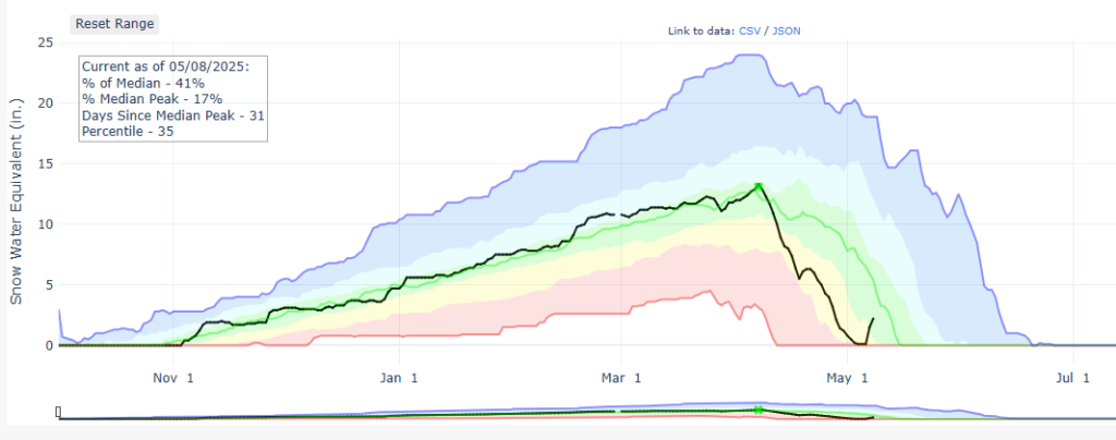
There’s an old saying that Colorado almost always has average snow years, while California almost never has average snow years – in California all years are way lower or way higher than average. And once again, we had a pretty average year here. For whatever reason, February was much better than normal, and April was worse than normal. May is off to a great start (2.2” of SWE at the Lake Eldora Snotel). Overall, we had a number of great storms, but an unfortunately warm spring until this past week. Here is the season graphically from the Lake Eldora Snotel, with green being average and black being this year.
Anyhow, I hope everyone enjoyed these forecasts, and I hope you have a wonderful summer of skiing on Colorado’s permanent snowfields until it starts snowing again in the fall.
-Jordan (Thursday 5/8/25)
Geeky Notes:
References to the American Model are to the American (GFS) Model grid including Brainerd Lake with an average elevation of 9,439’. References to the Canadian Model are the Canadian (GDPS) Model grid including Brainerd Lake with an average elevation of 10,253’. References to the WRF Model are the CAIC WRF Hi-Res Model point forecast for Eldora Ski Area with an elevation of 9,189’. References to the European Model are to the European (ECMWF) Model on a point with my cursor at my best estimate of Eldora Ski Area. For big picture overviews, I tend to rely on the American Model, not because I think it is the most accurate, but because (i) it is free and (ii) I like its interface.